A common mistake we see on Liverpool sites is relying solely on borehole logs without a continuous profile. The cone penetration test (CPT) catches thin weak layers between sampling intervals—something a standard shell and auger rig can miss entirely. On the Mersey silt banks, for example, a 50 mm soft lens at 4 m depth can trigger differential settlement under a framed structure. Continuous CPT logging at 20 mm intervals gives us real-time tip resistance and sleeve friction data. Before we mobilise, the team always reviews existing records and pairs the test with a calicatas exploratorias to confirm the upper stratigraphy.
A 50 mm soft layer between sampling intervals can trigger differential settlement under a framed structure in Liverpool's glacial till.
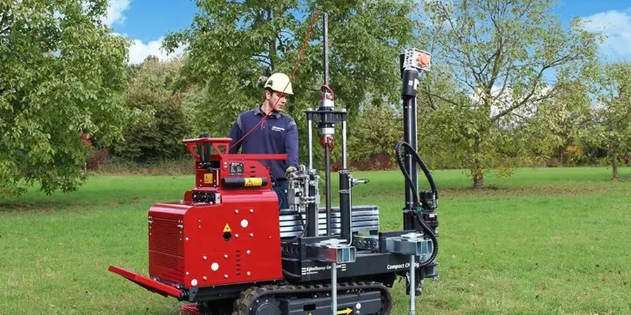
Process overview
Liverpool's ground is dominated by glacial till overlying Triassic sandstone, with the water table fluctuating between 2 and 5 m below surface across the city. The CPT cone measures end resistance (qc) and sleeve friction (fs) every 2 cm, which lets us identify the intact till, the weathered sandstone interface, and any soft alluvial pockets along the Mersey corridor. We follow the IRTP (International Reference Test Procedure) for calibration and apply a 10 cm² piezocone when pore pressure data is needed. The friction ratio (Rf = fs/qc) helps classify soils in real time—sands typically show Rf below 1 %, clays above 4 %. For granular strata we also run a presurometro directly after the CPT to obtain the modulus of deformation.
Technical reference image — Liverpool
Local context
The difference between the Bootle docks and the Allerton sandstone ridge is stark. In Bootle, soft estuarine clays up to 8 m thick can cause long-term consolidation settlements under embankments, while on the ridge the till is stiff and the water table is deep. A developer who assumes uniform till across Liverpool risks underestimating bearing capacity by 40 % in the low-lying zones. The CPT (Cone Penetration Test) captures these lateral variations with a resolution that no other in-situ method provides, reducing the chance of foundation redesign after excavation starts.
Pore pressure measurements at the u2 position for accurate soil classification and consolidation coefficient estimation in Liverpool's clays.
02
Seismic CPT (SCPT)
vs30/" data-interlink="1">Shear wave velocity profiles using a geophone embedded in the cone, ideal for dynamic design on Merseyside.
03
Environmental CPT
Combined geotechnical and groundwater sampling for contaminated land assessments on brownfield sites.
04
Continuous CPT Logging
Real-time qc, fs and pore pressure data acquisition at 20 mm intervals, delivered as digital files compatible with gINT or HoleBASE.
Relevant standards
BS EN ISO 22476-1:2012 (Geotechnical investigation and testing – Field testing – Part 1: Electrical cone and piezocone penetration test), BS 5930:2015 (Code of practice for ground investigations), Eurocode 7 – EN 1997-2:2007 (Ground investigation and testing)
Common questions
What is the difference between CPT and SPT?
The CPT (Cone Penetration Test) provides a continuous profile of tip resistance and sleeve friction at 20 mm intervals, whereas the SPT gives discrete blow counts at 1.5 m intervals. In Liverpool's interbedded till and sand, the CPT detects thin weak layers that the SPT can easily skip.
How deep can the CPT reach in Liverpool ground?
In the glacial till and underlying sandstone, a 20-tonne rig can typically push to 25 m before reaching refusal on the Triassic bedrock. In the softer estuarine deposits near the Mersey, depths of 35 m are common with a 15-tonne rig.
How much does a CPT survey cost in Liverpool?
A standard CPT sounding in the Liverpool area ranges from £110 to £190 per metre, depending on depth, access, and whether pore pressure or seismic sensors are required.
Do you provide a soil classification report?
Yes. We classify each 20 mm interval using the Robertson (1990) chart based on qc and Rf. The final report includes a stratigraphic column, strength parameters (undrained shear strength for clays, friction angle for sands), and a comparison with adjacent borehole logs.