Together, we solve the challenges of tomorrow.
SEE MORE →Geophysics in Liverpool represents a specialised branch of earth sciences that applies non-invasive survey techniques to investigate subsurface conditions without disturbing the ground. This category encompasses a range of methods designed to map geological structures, detect buried objects, assess ground stability, and characterise soil and rock properties. In a city with Liverpool's rich industrial heritage and ongoing urban regeneration, geophysical surveys have become indispensable for managing geological risks and ensuring safe, cost-effective development. From the historic docks along the Mersey to the expanding commercial districts, understanding what lies beneath the surface is critical for engineers, archaeologists, and environmental consultants alike.
Liverpool's underlying geology presents unique challenges that make geophysical investigation particularly relevant. The city is largely underlain by Triassic sandstones of the Sherwood Sandstone Group, which form a major aquifer and have historically been exploited for building stone. However, overlying these competent rocks are complex sequences of glacial till, laminated clays, and alluvial deposits associated with the River Mersey and its tributaries. Areas of filled ground are widespread, especially across former docklands and industrial sites where centuries of human activity have left a legacy of made ground, buried foundations, and potential contamination. Natural cavities can occur within the sandstone, while mining legacy in the broader Merseyside region introduces subsidence risks that require careful assessment. These variable ground conditions demand site-specific geophysical investigation before any major construction or remediation work begins.
Geophysical surveys in the UK must comply with established standards and guidance, even though no single piece of legislation governs all such work. The British Standards Institution provides key documents including BS 5930 for site investigation and BS 8573 for ground investigation. For electromagnetic methods, practitioners follow guidance from the European Ground Penetrating Radar Association and relevant sections of Eurocode 7 for geotechnical design. When surveys are conducted near water bodies, the Environment Agency may require permits, and archaeological geophysics must adhere to standards set by Historic England and local planning authorities. In Liverpool specifically, the City Council's planning department often requests geophysical reports as part of applications involving brownfield sites, conservation areas, or locations near the UNESCO World Heritage waterfront. All surveys should be undertaken by qualified geophysicists who can demonstrate compliance with the UK's Construction (Design and Management) Regulations 2015.
The range of projects requiring geophysical input across Liverpool is remarkably diverse. Pre-construction site investigations for residential and commercial developments routinely incorporate electrical resistivity surveys to map buried services, assess ground conditions, and delineate contamination plumes. Transport infrastructure projects, including upgrades to the Merseyrail network and highway expansions, depend on GPR surveys to locate utilities and assess ballast and pavement integrity without excavation. Heritage and conservation work around the city's Georgian and Victorian architecture frequently calls upon HVSR microtremor surveys to evaluate ground stability and resonance characteristics that might affect sensitive structures. Additionally, renewable energy schemes such as ground source heat pump installations require geophysical mapping of subsurface thermal properties, while flood defence improvements along the Mersey rely on resistivity profiling to understand levee and embankment condition. Each project type benefits from the tailored application of appropriate geophysical techniques that minimise intrusive investigation and reduce overall project risk.
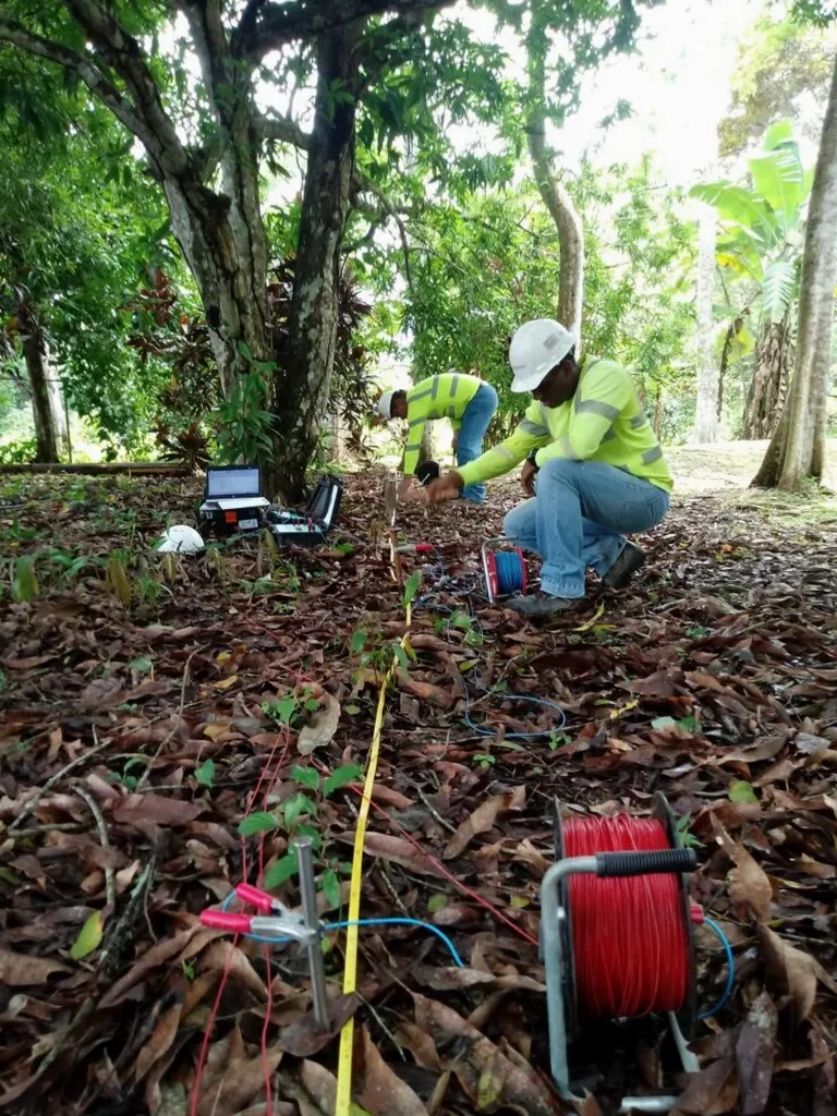
Geophysics involves measuring physical properties of the subsurface—such as electrical resistivity, electromagnetic wave velocity, or seismic response—using non-invasive surface-based instruments. In site investigations, these methods help identify buried structures, map geological layering, detect voids, and delineate contamination without the need for extensive drilling. The resulting data guides targeted intrusive sampling and reduces overall project uncertainty, making geophysics a cost-effective preliminary investigation tool for Liverpool's complex ground conditions.
The principal methods include ground penetrating radar (GPR) for shallow high-resolution imaging, electrical resistivity tomography for mapping moisture and lithological variations, and seismic techniques such as HVSR for assessing ground stiffness and resonance. Magnetic and electromagnetic surveys are also common for locating ferrous objects and mapping conductive ground. The choice depends on site geology, target depth, and the specific engineering or environmental question being addressed, always guided by British Standards and Eurocode 7 principles.
Liverpool City Council typically requires geophysical surveys for developments on brownfield land, within conservation areas, or near known archaeological sites. Projects involving deep excavations, piling, or work adjacent to the Mersey waterfront often trigger the need for subsurface investigation. The survey forms part of the geotechnical desk study and ground investigation report submitted with planning applications, demonstrating that ground risks have been adequately assessed in accordance with national planning policy and local development guidelines.
Depth penetration varies significantly by method: GPR typically reaches 5-10 metres in Liverpool's clay-rich soils, while electrical resistivity can image tens of metres deep. Seismic methods may reach bedrock at over 30 metres. Limitations include signal attenuation in saturated clays, cultural noise from urban infrastructure, and resolution decreasing with depth. No single technique provides a complete picture, so integrated surveys combining complementary methods are recommended to overcome individual limitations and deliver reliable subsurface models.