Liverpool’s geology is dominated by thick glacial till overlying Triassic sandstones, a sequence that lends itself to both stable foundations and sudden failure in cut slopes. The till itself varies from dense, sandy clay to loose, water-bearing lenses, especially near the Mersey estuary where groundwater levels shift with the tide. In our experience, a thorough landslide assessment in Liverpool must start with understanding this layered profile, because a seemingly solid upper crust can mask a soft, saturated zone just a few metres down. We routinely combine borehole logging with resistivity surveys to map those hidden contrasts before they become a problem. The city’s humid maritime climate only adds to the challenge, keeping soils wet for much of the year and reducing effective stress in vulnerable slopes.
A slope that looks dry in July can fail in January when the till reaches full saturation after weeks of Atlantic rain.
Process overview
Compare a slope in the sandstone ridge of Woolton with one in the alluvial flats of Speke, and you see two completely different failure mechanisms. In Woolton, failures tend to be translational along bedding planes in the weathered sandstone; in Speke, they are rotational slumps in soft clay. A proper landslide assessment in Liverpool has to account for these contrasts, adjusting both field methods and laboratory protocols to suit the local material. For example, we run different shear-strength tests on till versus sandstone residual soils, and we always check for perched water tables in the upper till layers. To get a full picture, we often pair the assessment with a stability analysis that models the worst-case seasonal saturation. The team then cross-references borehole logs, inclinometer data, and piezometric records to confirm whether a slope is creeping or genuinely unstable.
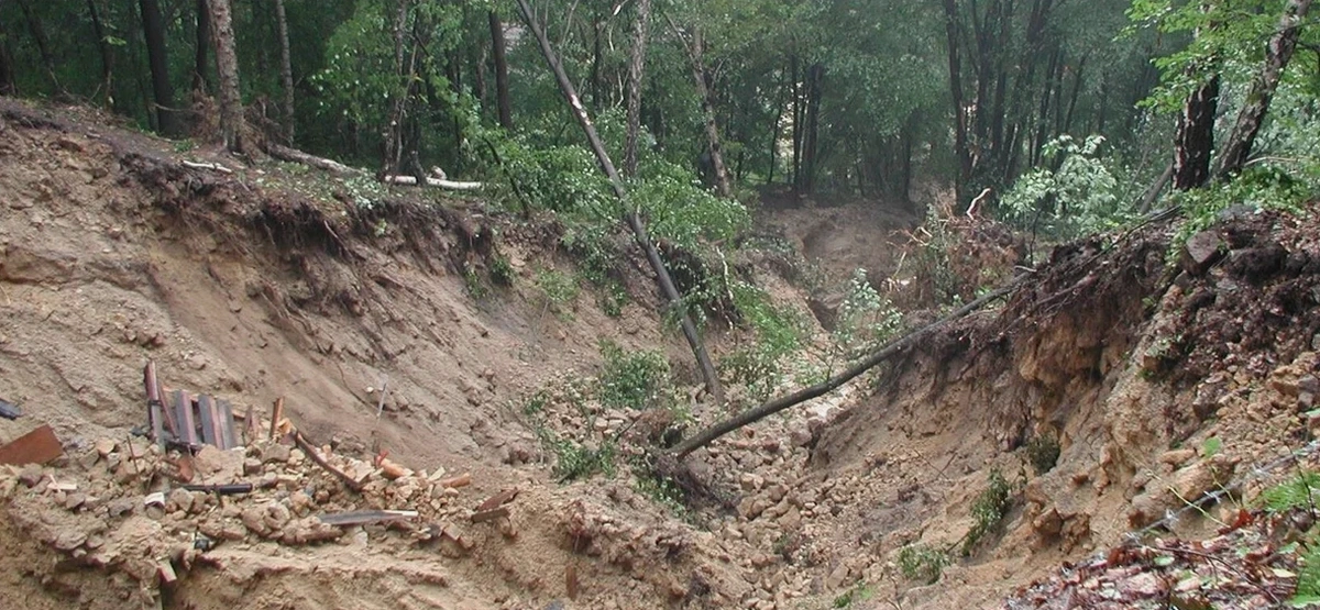
Technical reference image — Liverpool
Local context
The biggest risk we see on Liverpool slopes is hidden seepage. A slope that looks stable from the surface might have a thin sand seam within the till that channels water and slowly reduces strength over years. We deploy vibrating-wire piezometers and standpipe installations precisely because of this—surface observations alone miss the story below. Another common hazard is the legacy of historic quarrying along the Mersey banks; old backfilled workings create weak zones that only a targeted landslide assessment can expose. In our fieldwork, the team drills through the till into the sandstone bedrock to check for open joints that could act as drainage paths or, conversely, as planes of weakness in heavy rain.
Glacial till (boulder clay) over Triassic sandstone
Typical shear strength (undrained)
cu = 40–120 kPa (till); 20–60 kPa (alluvial clay)
Groundwater regime
Perched in upper till; artesian in sandstone fractures
Failure mode common in area
Rotational slumps in clay; planar slides in weathered sandstone
Annual rainfall (Liverpool average)
~690 mm — moderate but persistent
Typical factor of safety target
1.3–1.5 (static); 1.1 (seismic, per Eurocode 7)
Additional services
01
Slope Stability Analysis
Limit-equilibrium and finite-element modelling for both static and seismic conditions. We calibrate soil parameters using site-specific lab results from the till and sandstone formations common to Liverpool.
02
Field Instrumentation & Monitoring
Installation of inclinometers, standpipe piezometers, and surface movement markers. Continuous data logging over wet and dry seasons to capture seasonal changes in pore pressure and displacement rates.
03
Laboratory Strength & Permeability Testing
Triaxial and direct shear tests on undisturbed till samples, plus falling-head permeability tests on sand seams. All testing follows BS 1377 and ISO 17025-accredited procedures.
Relevant standards
BS 5930:2015 (Code of practice for ground investigations), Eurocode 7 – BS EN 1997-1:2004 (Geotechnical design – general rules), FHWA-NHI-05-089 (Slope stability reference manual)
Common questions
How much does a landslide assessment cost in Liverpool?
A typical landslide assessment for a residential slope in Liverpool ranges from £840 to £2,640, depending on the site complexity, number of boreholes, and whether monitoring is required. The cost increases for large-scale developments or when deep boreholes into the sandstone are needed.
What signs indicate a slope in Liverpool might be unstable?
Look for tension cracks near the crest, leaning trees or fence posts, bulging ground at the toe, and damp patches that persist long after rain. In Liverpool’s till, small scarps just a few centimetres high often precede a larger rotational failure.
Do I need planning permission for a landslide assessment on my land?
For exploratory boreholes and trial pits, you generally do not need full planning permission, but you must notify the local authority if drilling near a public highway or a listed structure. The Coal Authority should also be informed if the site lies within a mining area.
How long does a typical landslide assessment take from start to finish?
A standard assessment takes 3 to 6 weeks: one week for fieldwork (drilling and instrumentation), two weeks for laboratory testing, and one to two weeks for analysis and reporting. If long-term monitoring is required, the overall programme extends to cover at least one wet season cycle.